Scaling Urban Carbon Prediction: How CarbonCLIP Bridges the Satellite-to-Street Gap
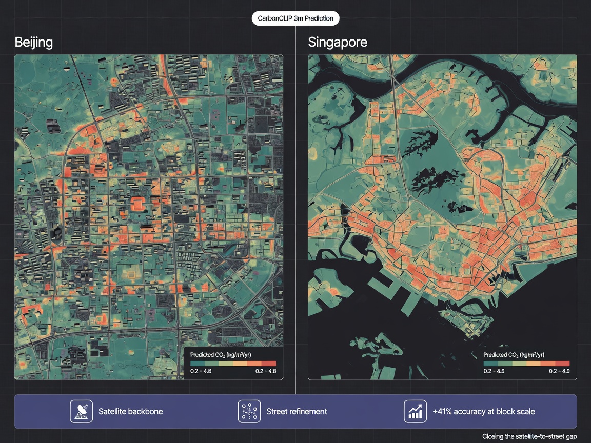
CarbonCLIP uses multimodal distillation to predict urban carbon emissions using only satellite imagery. By bridging the gap between top-down views and ground-level activity during pretraining, it offers a scalable way to model emissions across diverse cities.
Automation needs a narrow first win
The best first AI workflow is usually a repeated task with a clear input, clear output, and a human approval step.
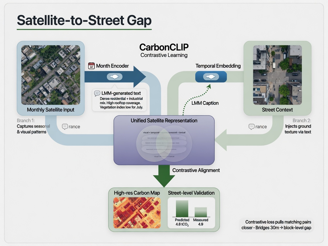
CarbonCLIP is a task-oriented multimodal distillation framework designed to solve a massive headache in remote sensing: data-source heterogeneity. Here’s the reality: it’s one thing to see a city from 3 meters up; it’s another thing entirely to understand the messy, fine-grained human activities driving carbon emissions on the ground. The researchers tackle this by transferring contextual knowledge into a unified satellite representation using a dual-branch contrastive learning approach.
Bridging the Gap with LMMs and Temporal Priors
The spatial branch of CarbonCLIP is where the real engineering magic happens. It uses fine-grained textual descriptions of street-view images to provide semantic priors. These aren't manually labeled; they're automatically generated by Large Multimodal Models (LMMs). By training the model to align satellite imagery with these text-based descriptions, the system learns to "understand" ground-level activity without needing that data during the actual prediction phase. To round out the picture, the temporal branch uses a month encoder to capture monthly emission variations. It’s a clever way to bake in "when" and "what" into a model that eventually only needs to see "where.
Worth a look
Phugialy Picks

The Agentic AI Bible: The Complete and Up-to-Date Guide to Design, Develop, and Scale Goal-Driven, LLM-Powered Agents that Think, Execute...

AI Engineering: Building Applications with Foundation Models
A practical guide to building real-world applications with foundation models and LLMs.

GMKtec K15 AI Mini PC Oculink Intel Ultra 5 125U 32GB DDR5 512GB SSD | Desktop Computer AI Boost, 3X M.2 2280 Storage Expansion, Dual NIC...
Some Phugialy Picks use affiliate links. If you buy through one, Phugialy may earn a commission. It doesn't change what we recommend. Full disclosure →
The Builder’s Take: Pretrain-Heavy, Inference-Light
From a production standpoint, the most pragmatic thing about CarbonCLIP is its distillation nature. It requires multimodal data—street-view images and temporal encoders—only during the pretraining phase. During inference, it relies solely on satellite imagery. This is a huge win for scalability. If you’re trying to model emissions across diverse cities, you don't want to be hunting for ground-level data that might be too expensive, unavailable, or too inconsistent to standardize. By distilling that knowledge into the satellite representation, CarbonCLIP allows us to maintain high-fidelity insights without the logistical nightmare of ground-truth collection at scale.
The Real Bottleneck: Pipeline Integrity
The real story here isn't just the "how"—it's the trade-off between pretraining complexity and inference simplicity. CarbonCLIP is a "pretrain-heavy, inference-light" architecture. While it makes deployment scalable, the bottleneck shifts to the pipeline required to generate high-quality, consistent textual descriptions from street-view images using LMMs. If those descriptions lack nuance or suffer from geographic bias during pretraining, that error becomes a permanent feature of the unified satellite representation. For anyone looking to deploy this, the question isn't just "can we do it?" but "how much diversity does our pretraining set need to handle the heterogeneity of global cities?" If the model learns "urban" from a Western-centric set of street views, its performance in diverse global contexts might hit a ceiling that current benchmarks don't fully expose.
Got a question about how this applies to you? →
Keep reading
Follow the thread

From Content Grind to Creative Flow: How AI is Your New Secret Weapon
Let’s be real: the content treadmill is exhausting. We’ve all felt that soul-crushing friction—the endless cycle of trying to draft the "perfect" caption while your creative spark fizzles out. But here is the incredible
Read this noteSame lane, different angle
Federated Learning’s Storage Problem: How FedCVESA Turns Models Into Data Theft Channels
If we're just swapping one storage risk for another, the whole 'privacy-first' pitch for Federated Learning starts to look like a marketing trick.
From 'No Entry' to 'Guest List': How Cloudflare is Giving Creators the Remote Control
For a long time, web owners have been stuck in a frustrating digital stalemate. You either let the bots in and watch your unique content get scraped into a black box, or you build a fortress so high that you accidentally